Over the years I’ve become quite good at explaining to others what Saskatchewan looks like. It’s more than just 7 hours across and a whole bunch of farmland. If you take the time to get off Highway 1 you’ll find yourself in one of the most unique and beautiful provinces in Canada. Case and point, drive south to the Big Muddy Badlands and see what I mean.

Country Roads, Take Me Home
On my recent trip back to my home province of Saskatchewan I decided it was time I get photographic proof of my explantations. My solo mission through Saskatchewan was to be a rediscovery of my home province. I made sure to take in parts of Saskatchewan I hadn’t seen in years, and some I’d never seen at all.

Drive South on HWY 6
Driving south from Regina will gradually take you through a sequence of topographies. Now you might be laughing at the use of the word “topographies” while describing Saskatchewan. “Isn’t it pretty flat there?” is the typical response from someone who’s never seen much of the prairies. Sure, we’ve got a few hundred thousand square kilometers of flatlands, but there’s more to it than that.

Rolling Prairie Hills
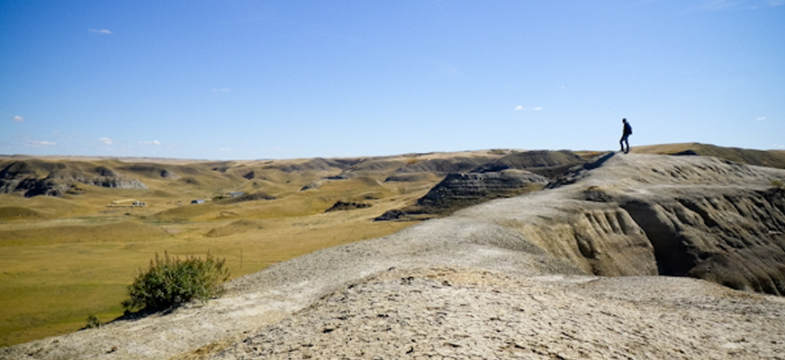
After roughly 2 hours of driving south, you’ll come across the rolling prairie hills. They’re still farmed like the flatlands, and still feel like “Saskatchewan”, but these hills have an uncanny ability of stealing your attention. As you continue driving, these rolling hills turn into something totally different. The fields of wheat, canola, and barley begin to disappear as you arrive in one of my favourite regions of Saskatchewan. The Big Muddy Badlands! Even saying it aloud makes you feel like a cowboy.
The Big Muddy Badlands
The Big Muddy Badlands are located along the Big Muddy Creek and extend all the way to Montana. They’re located inside the Big Muddy Valley. This unique valley is 55 kilometres [34 mile] long, 3.2 kilometres [2mile] wide & 160 metres [520 feet] deep. It’s one of the driest and most rugged regions of Saskatchewan.

What Goes on in the Big Muddy?
Bandits! Well, there used to be bandits. Back in the late 1800’s and early 1900’s the Big Muddy Badlands formed the northern tip of the Bandit Trail. This trail was used by world renown horse bandits Sundance Kid, Dutch Henry, Pigeon Toed Kid, Coyote Pete, and my personal favourite, Sam Kelly (more on him in a later post).
Nowadays the Big Muddy is known for its Horseback riding, cattle ranching, farming, and some of Saskatchewans most exciting highway drives. The rocky cliffs and carved out valleys are so foreign after hours of flatland, that its hard to believe you’re actually still in Saskatchewan.
It’s easy to get distracted in the Big Muddy. I had to remind myself that I was here for a reason. I was trying to find Castle Butte, a 70 meter relic from the ice age; similar to Uluru (In Australia), only on a smaller scale. I had stumbled upon it years ago online and decided I had to check it out.

Finding Castle Butte
One would assume that it’d be easy to spot, but it’s actually surprisingly tricky to find. Highways in this part of Saskatchewan can be tough to navigate, signs tend to be few and far between. While some may find this to be a minor inconvenience, I quite enjoy getting lost and finding my way back onto the correct path. It typically leads to a few self deprecating laughs.
Turning onto Highway 34, south of Bengough, I finally see a sign indicating I’m on the right track. I drive through a texas gate, and begin to wonder if I’m trespassing on someones property. I ignore that thought and continue on. Signs don’t lie, do they?

Thar she be!
As the gravel road curves, I spot it. Looming over the dry pasture land is Castle Butte. I snap a few pictures from afar and continue on. As I drive up the winding road a welcome sign greets me. I park my car at the base of the ancient monument and look up.

Welcome to Castle Butte
Gazing up at this massive prairie goliath I laugh in excitement. I start by doing a full lap around the perimeter of Castle Butte, deciding whats the best route to begin the climb. As I complete the full 360 degree circle I realize that the first walkway up was the best. Before setting out to climb, I decide to check out some of the small caverns that have been erroded into the sandstone & clay.

A Small Saskatchewan Cave
I climb into the darkness, using the flash of my camera to see how far this Saskatchewan cave goes. It appears to narrow out at about 12 feet at which point it stops. The cave juts in and out at all angles, making for an awkward crawl. I bump my head twice and rub the location of impact. I’m clearly not cut out for spelunking.

Ryan Was Here
I feel my way out and spot several carved names inside the cave. Looks like “Ryan” beat me here. I exit the tiny cave and breathe a sigh of relief for not being crushed to death by Castle Butte. The sun is still shining and this giant piece of rock is calling my name.

Commencing the Climb
I began climbing, carefully stepping between crevices, hoping with each step that I don’t lose my grip and roll to the bottom. The first half of the climb is mostly just a steep walk. As I get about halfway up it picks up in difficulty. While it’s by all means not the toughest climb, there are a several spots that require all four limbs and a decent balance.

Pause & Picture
I paused to catch my breathe and snap a couple photos as I approached the top of Castle Butte. Looking back down below provided an incredible view of the Big Muddy Badlands. I smiled and pushed on. “Only 15 feet or so before I’m able to comfortably stand and relax.” I thought to myself.

King of the Castle
I reached the top of Castle Butte and pulled myself up. As I regained my posture I commenced the first among many 360s. The vista that was before me was a mix of prairie flatlands, harsh rocky cliffs and badlands. The blue sky above shined down on what had to be one of the warmest fall days in Saskatchewan history.
I snapped a few photos and found a spot to place my backpack. Just as I was about to relax my phone began kicking off in my pocket. I laughed to myself “Looks like I’m back in cell phone reception“. I opened a newly received email from my Grandma. “Hows the trip going?” she asks. I decided to take advantage of the reception and send her a few photos and explain exactly where I am, knowing she’ll get a kick out of it. Bernice is awesome that way!

I must have spent nearly an hour on the top of Castle Butte. During that hour I didn’t see a single human soul. Not even one car drove by. The closest thing to company was a small herd of black angus cattle a couple miles away who would occasionally hollar out “hello” to me. Sitting on the top of Castle Butte I said a quick thank you to the last ice age for being so awesome and carving this giant monster out of the prairies. This relic of a landmark is hands down one of the coolest places I’ve ever been to in Saskatchewan.
Note: Castle Butte isn’t pinned on Google Maps yet so I managed to use my phones GPS to grab the coordinates and mapped them below. This might be the only modern map to Castle Butte so use it wisely. If you get lost there are a few service stations in the area that might be able to offer directions. The town of Coronach is the tourism hub for this region so they should be helpful as well.
[mappress]